FAA Cameras Map Layer
- Make more informed go/no-go decisions with live views from over 500 FAA WeatherCams in 24 US states providing visibility into real-time weather and runway conditions.
- Access cameras at the top of Airports > Info for airports with on-field cameras, or enable the Cameras map layer to find available feeds on the map, represented by camera icons with arrows indicating the direction of each camera view.
- Tap on a camera icon to preview its latest images in the Maps sidebar, and tap any image to open it in a larger window with zoom support as well as details about the direction of each view and the age of the current image, which is usually less than 30 minutes.
- The full Cameras window also allows you to compare the latest images with corresponding "Clear Day" reference images using a toggle in the top-right corner of the window.
- Camera images along your route are automatically downloaded for offline access when you Pack for a flight.
- The majority of camera sites are located in Alaska, Hawaii, Maine, and the western CONUS, but new cameras will automatically become available as the FAA installs them.
- The Cameras map layer is available with ForeFlight Essential subscriptions and above.
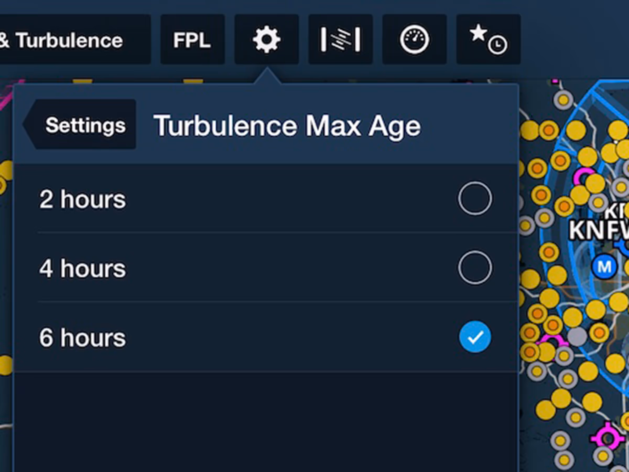
Reported Turbulence: Maximum Age Setting
- Hide older turbulence reports with a new setting to limit the maximum age of the Reported Turbulence layer.
- The Turbulence Max Age setting is available in the Map Settings menu as well as More > Settings > Map View for all accounts with access to Reported Turbulence.
- The default setting is 6 hours, with additional settings for 4 and 2 hours to show only the most recent turbulence reports.
- Reported Turbulence is available to individuals with ForeFlight Essential and Premium plans after registering a Sentry or Sentry Plus device on ForeFlight Web. Business customers may contact ForeFlight Sales to inquire about Reported Turbulence.
Airport Tab in ForeFlight Web
- Access airport information more directly with a dedicated tab in ForeFlight Web on the web with easier access to airport information and airport search.
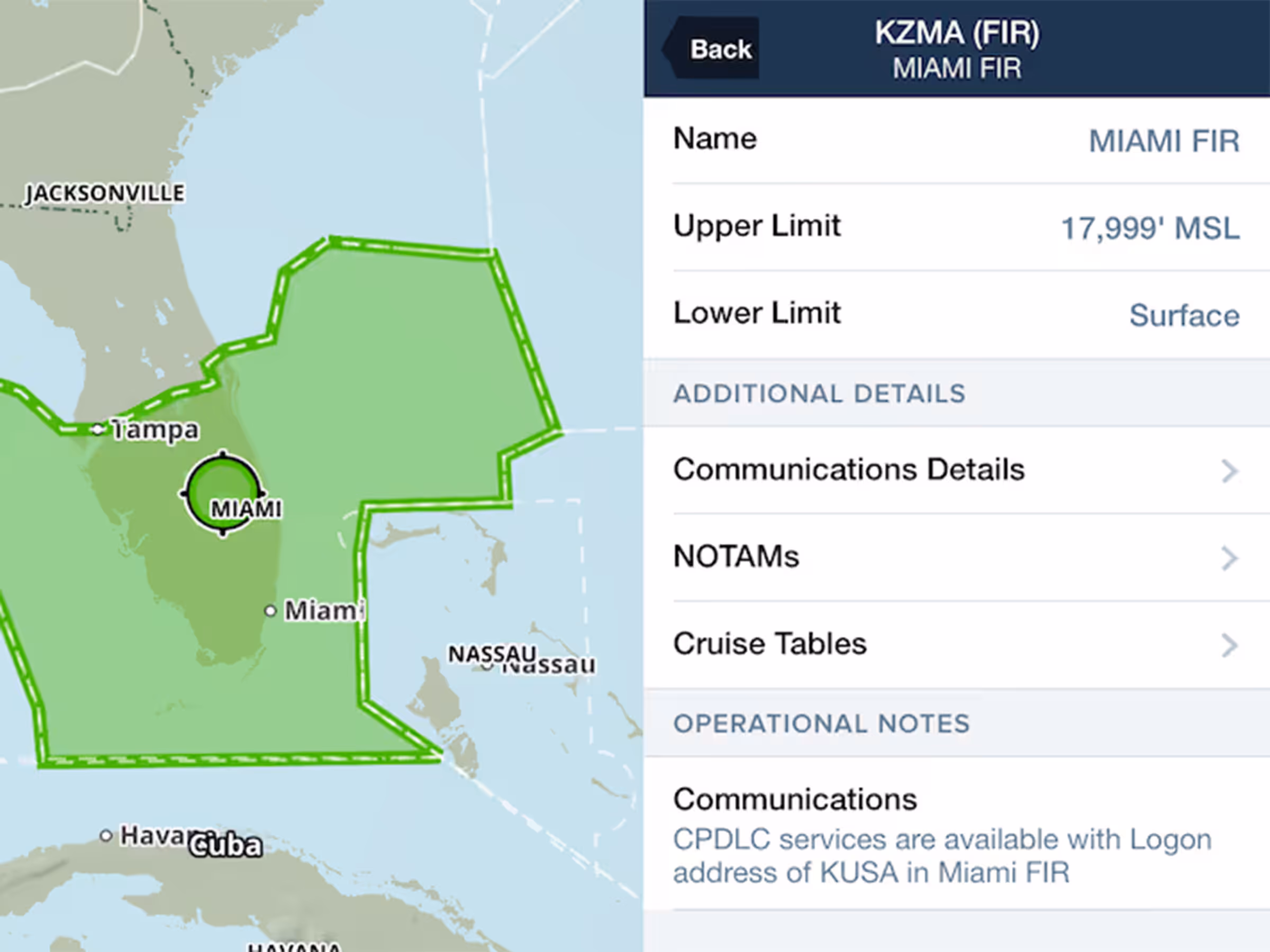
NOTAMs in ARTCC/FIR Details
- NOTAMs that relate to airspace within an FIR/UIR are now quickly viewable on the map from each one’s Airspace Detail view.
- Tap-hold on an FIR/UIR on the map and tap Details next to the airspace name in the list, then tap NOTAMs to review all notices for that facility.
Expanded Airport Contacts
- Access more detailed airport contact information in Airports > Info > Contacts.
- In addition to name, phone number, and address information, the list of airport contacts now supports fax and clickable websites and email addresses.
Dark Mode App Icon
- ForeFlight's app icon now supports Dark Mode on iOS/iPadOS 18 and above.
New Zealand Support
- Plan and fly in New Zealand with Aeropath-sourced charts, procedures, and documents.
- Pilots with the New Zealand subscription region can access VFR and IFR enroute charts, procedure and aerodrome charts, as well as AIP, AIC, and supplemental documents.
- Enable the New Zealand chart and procedure downloads in More > Downloads > Regions > New Zealand.
- New or existing ForeFlight customers can add the New Zealand region to their subscription on ForeFlight's website to access this data.


.avif)