Each time I open the ForeFlight app and tap on my local airport, I do what many pilots do- glance at the TAF section and hope for that stack of beautiful green lines. It’s a quick visual cue that my VFR flight is looking good, weather-wise. But beyond that reassuring green lies a deeper layer of information that every pilot should understand.
From code to clarity: What TAFs really tell you
TAFs, or Terminal Aerodrome Forecasts, are an essential part of preflight planning. While the raw, coded format can look intimidating at first glance, ForeFlight makes it incredibly easy to break it all down. One of my favorite features is the option to scroll down and view the full decoded version, translating each line into plain, pilot-friendly language.
Get to know the forecast discussion
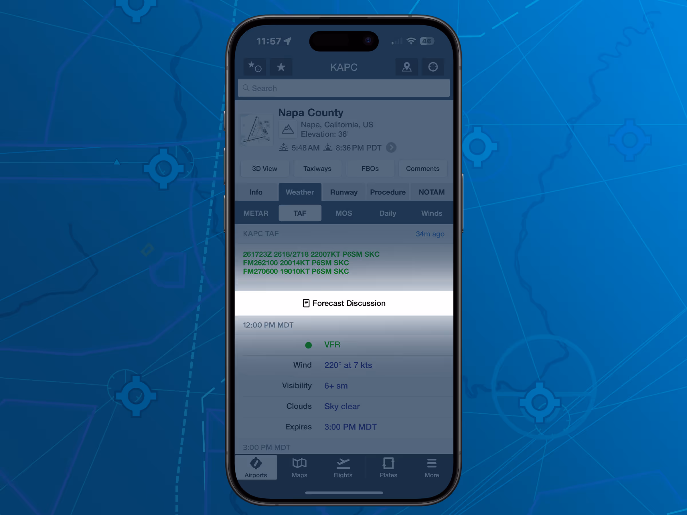
Equally as valuable, especially from my perspective as a TV meteorologist, is the forecast discussion tucked between the lines. This section, written by the meteorologists who issue the TAFs, gives insight into why certain conditions are forecasted, adding valuable context to your briefing. It may say something like, “Winds expected to shift due to frontal boundary passage,” or “Low stratus may linger longer than models indicate.” These little nuggets help you anticipate possible changes– something no static TAF line can do alone. I read it daily for my job, and if it’s not already part of your preflight routine, I highly recommend making it one.
TAF anatomy: Breaking down a real example
So, let’s talk more about those (hopefully) green lines. TAFs are concise, coded weather forecasts specifically issued for airports. They’re published four times daily and typically cover a period of 24 to 30 hours. These forecasts are issued by certified meteorologists and give you a time-specific look at expected weather conditions, like wind, visibility, significant weather, and cloud cover.
Let’s break one down.
Say your TAF looks like this:
KSMF 281120Z 2812/2912 35005KT P6SM SKC
FM281600 32010KT P6SM FEW050
FM282300 VRB04KT P6SM SCT250
FM290800 00000KT 5SM BR FEW002
At first glance, it can look like alphabet soup, but each section is packed with helpful information.
- KSMF is the ICAO identifier for Sacramento International Airport.
- 281120Z is the date and time the forecast was issued—in this case, the 28th at 1120 Zulu time.
- 2812/2912 is the valid time of the forecast, from the 28th at 1200Z to the 29th at 1200Z.
Each subsequent line describes weather conditions starting at a specific time:
- FM281600 32010KT P6SM FEW050: From the 28th at 1600Z, the wind is from 320° at 10 knots, visibility greater than 6 statute miles, and a few clouds at 5,000 feet above ground level.
- FM282300 VRB04KT P6SM SCT250: From 2300Z, winds become variable at 4 knots, visibility stays good, and scattered clouds at 25,000 feet.
- FM290800 00000KT 5SM BR FEW002: From 0800Z on the 29th, calm winds, 5 statute miles visibility with mist (BR is the code for mist), and a few clouds at just 200 feet.
Each element is carefully chosen for aviation relevance. Wind direction and speed help you choose runways. Visibility and cloud coverage guide your VFR versus IFR planning. And any codes like RA (rain), TSRA (thunderstorms with rain), FG (fog), or SN (snow) let you know quickly if your route may be impacted.
ForeFlight’s TAF decoder: Your new best friend
Now, if you’re just reading this coded version from a text product on the FAA website or a METAR/TAF feed, you’d probably need a cheat sheet handy. That’s where ForeFlight comes in clutch. With one tap, you can see that same TAF decoded into plain English, no guessing required.
For example, ForeFlight would decode the line as:
From 1600Z, winds from the northwest at 10 knots, visibility greater than 6 statute miles, few clouds at 5,000 feet.
So much easier to digest when you’re juggling preflight planning, passenger coordination, and performance calculations.
Graphical TAF view: Forecasting made visual
Even better, the graphical TAF view in ForeFlight visually breaks down wind, ceiling, and visibility trends by the hour. You can watch expected weather conditions rise and fall like a stock chart. This is invaluable for timing your departure or arrival to avoid marginal conditions.

How pilots can incorporate TAFs into their preflight ritual
- Check the raw TAF - get used to reading the codes.
- Scroll to the decoded version - confirm your interpretation.
- Read the forecast discussion - understand the reasoning.
- Use graphical tools - visualize how conditions evolve over time.
- Compare with nearby stations - airports within 30-50 miles can give you an early warning for shifting weather.
TAFs are just one piece of the bigger weather briefing puzzle, but they’re one of the most precise tools we have for flight planning, especially within the airport environment. ForeFlight’s smart layout, visual cues, and layered briefings remove the guesswork, especially when time is tight or pressure is high. I’ll be highlighting more weather related tools and topics in the weeks to come.
Final thoughts: Why a green line isn’t always enough
As pilots, it’s tempting to let green lines go without question, but remember: understanding the "why" behind the forecast makes you a safer, smarter aviator. So next time you’re scrolling through ForeFlight with a cup of coffee before a flight, don’t just look for green or red. Take a moment to decode, digest, and discuss the forecast like the PIC you are.
Weather may always be the wildcard in aviation, but with tools like TAFs and apps like ForeFlight, it doesn't have to be a mystery.

.jpg)