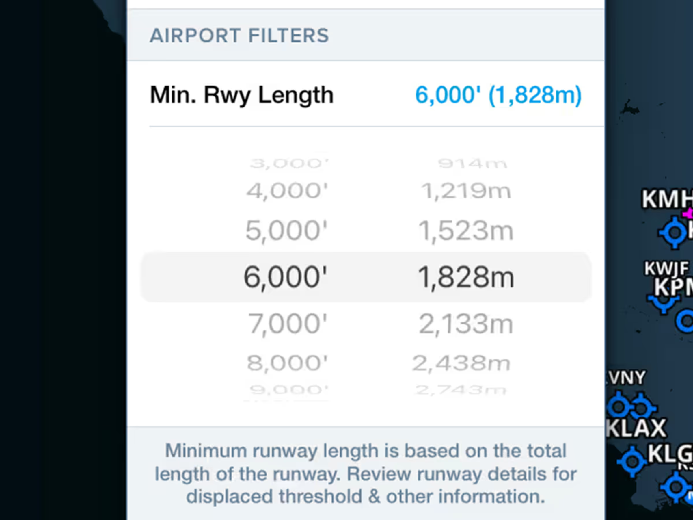
Airport Runway Length Filter
- Declutter the Aeronautical Map by hiding airports with runways shorter than a set length.
- Access the filter in Map Settings > Airports while the Aeronautical Map is enabled and set a minimum runway length in either feet or meters between 3,000 and 10,000 feet, or 914 and 3,047 meters.
- A blue rectangle in the lower-right of the Maps view indicates the current filter length while it’s enabled, and you can tap on this to change or disable the filter along with other Airport settings.
Profile Corridor
- Visualize Profile View on the overhead map and easily see the highest hazards near each leg of your route.
- Enable either Profile View or Hazard Advisor to activate the corridor. The highest obstacle and terrain feature within the corridor on each leg of your route are identified with small markers labeled with their elevations.
- Tap on any leg in your route to view the elevations of the highest obstacle and terrain feature along that leg.
- With Hazard Advisor enabled, the markers are colored yellow or red to indicate their elevation relative to your planned or current altitude and also respond to changes to the Hazard Advisor Altitude Slider.
- Change when the Corridor is activated (automatically, always, or never) in Map Settings > Corridor Activation, and change the width of the corridor (8nm by default) both on the map and in Profile View using the Settings cogs in Profile View or in Hazard Advisor’s map legend.
- Available with Essential plans and above.
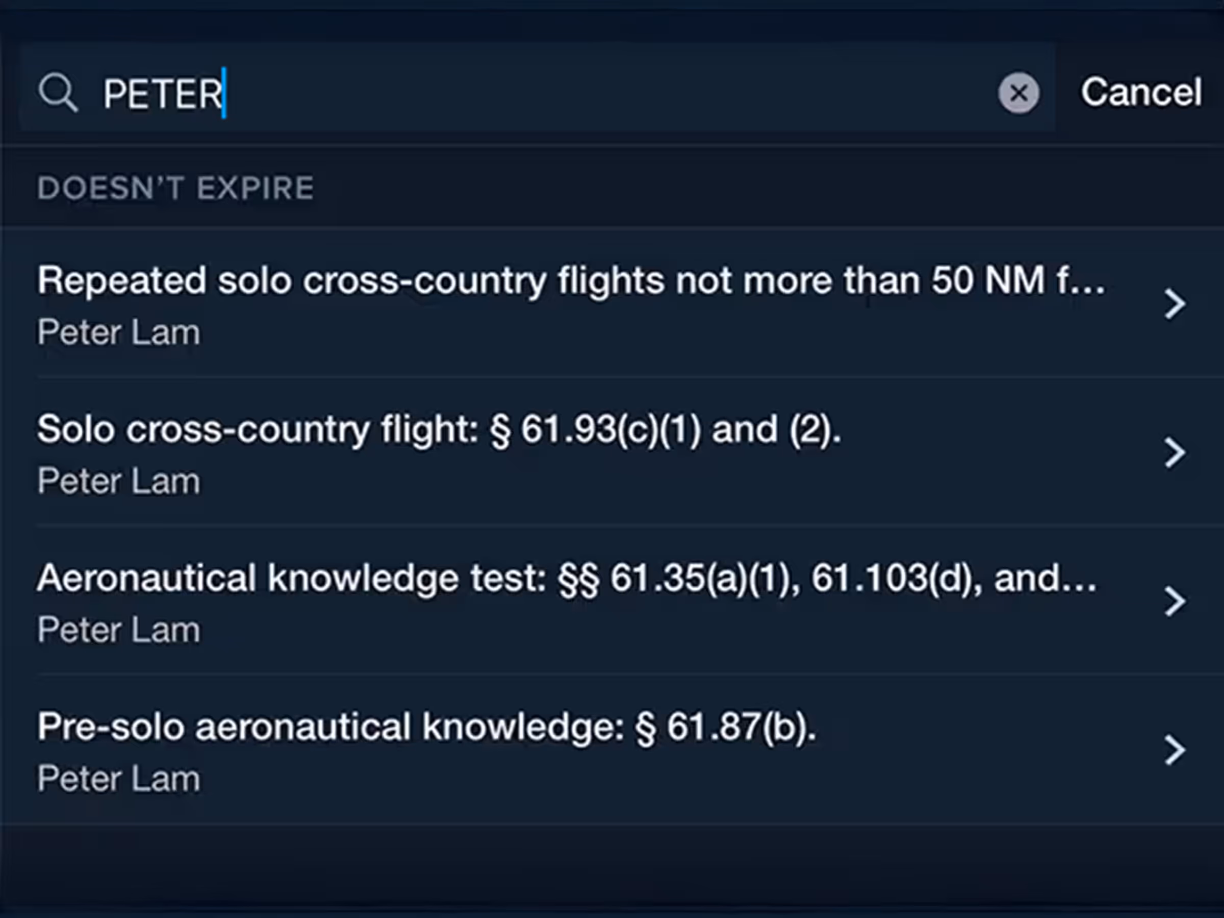
Logbook Instructor Tools Enhancements
- Endorsements listed in Logbook > Instructor Tools > Endorsement Records now include each one’s FAA regulation reference to more easily identify them, and a new search filter at the top of the view makes it easier to find past endorsements.
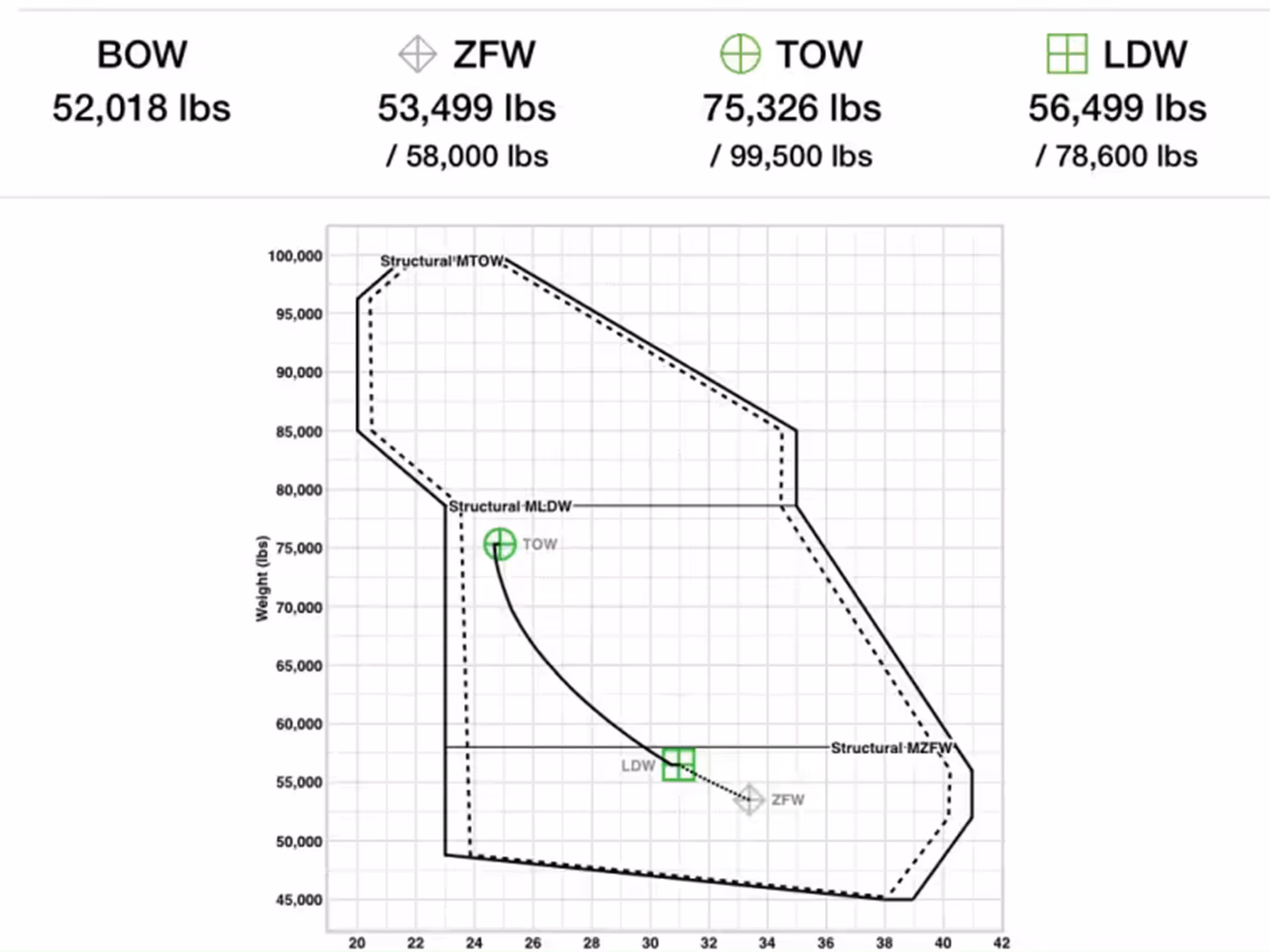
W&B Envelope Curtailment
- Curtail your Weight & Balance envelope to account for variations in passenger weight when using standard weights.
- A new Curtailment Options section below the W&B graph provides a Standard Weights switch which, when enabled, adds a dotted curtailment line to the W&B envelope.
- Customize the Standard Deviation used to calculate curtailment in More > Settings > Standard Weights, which is set to 47 by default based on NHANES data listed in AC 120-27F.
- Available for ForeFlight Business and Military Flight Bag customers.
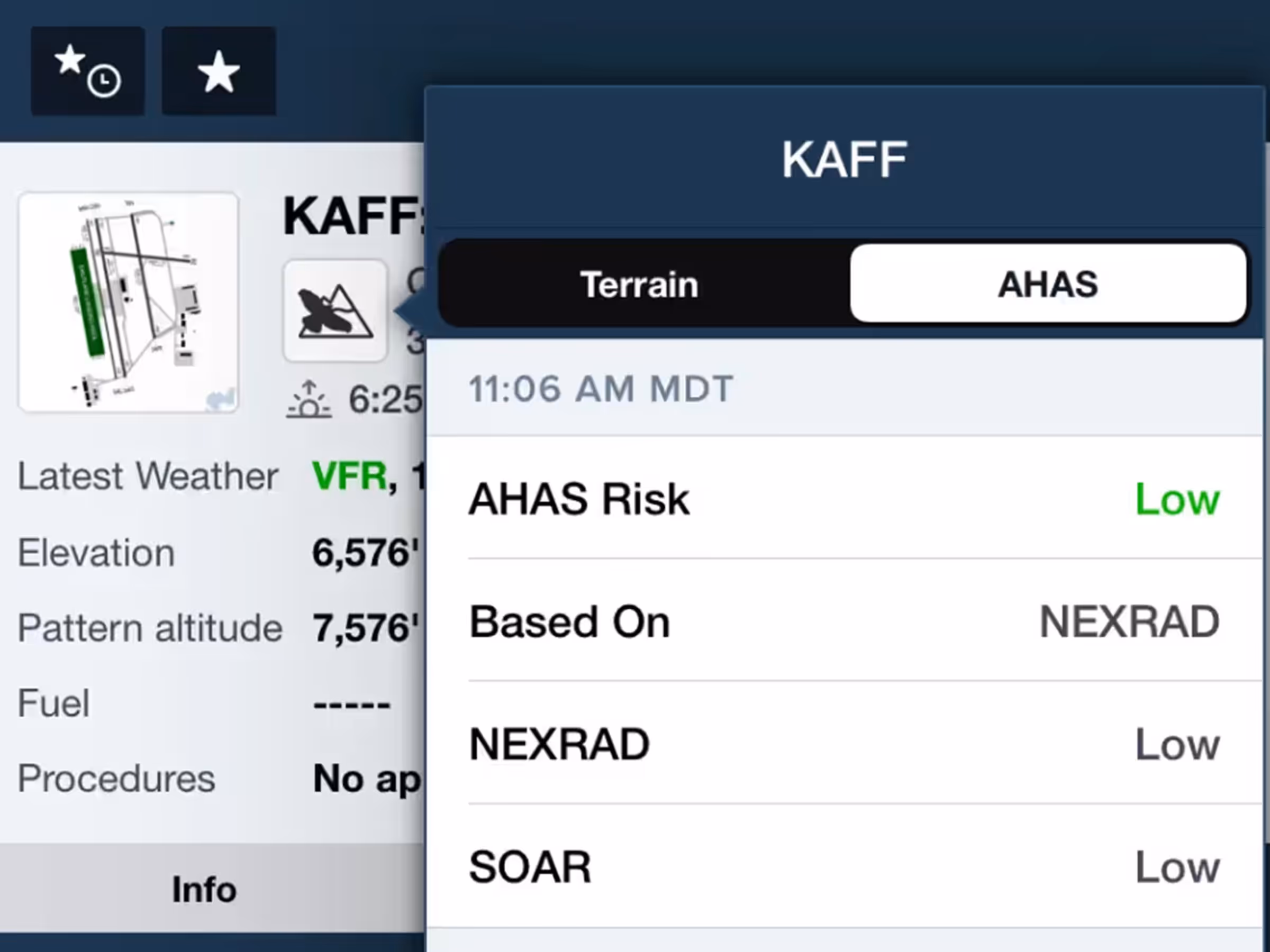
MFB One - Avian Hazards Forecast
- Get a consolidated view of all available military bird forecasts (NEXRAD, BAM, and SOAR) for supported airports.
- Supported airports are indicated by a bird or bird + mountain icon just below the airport’s name in the Airports view or in any airport popup.
- Tap the icon to view all available USAF AHAS forecast data for the next 10 hours.
- Available with ForeFlight’s Military Flight Bag One subscription plan.
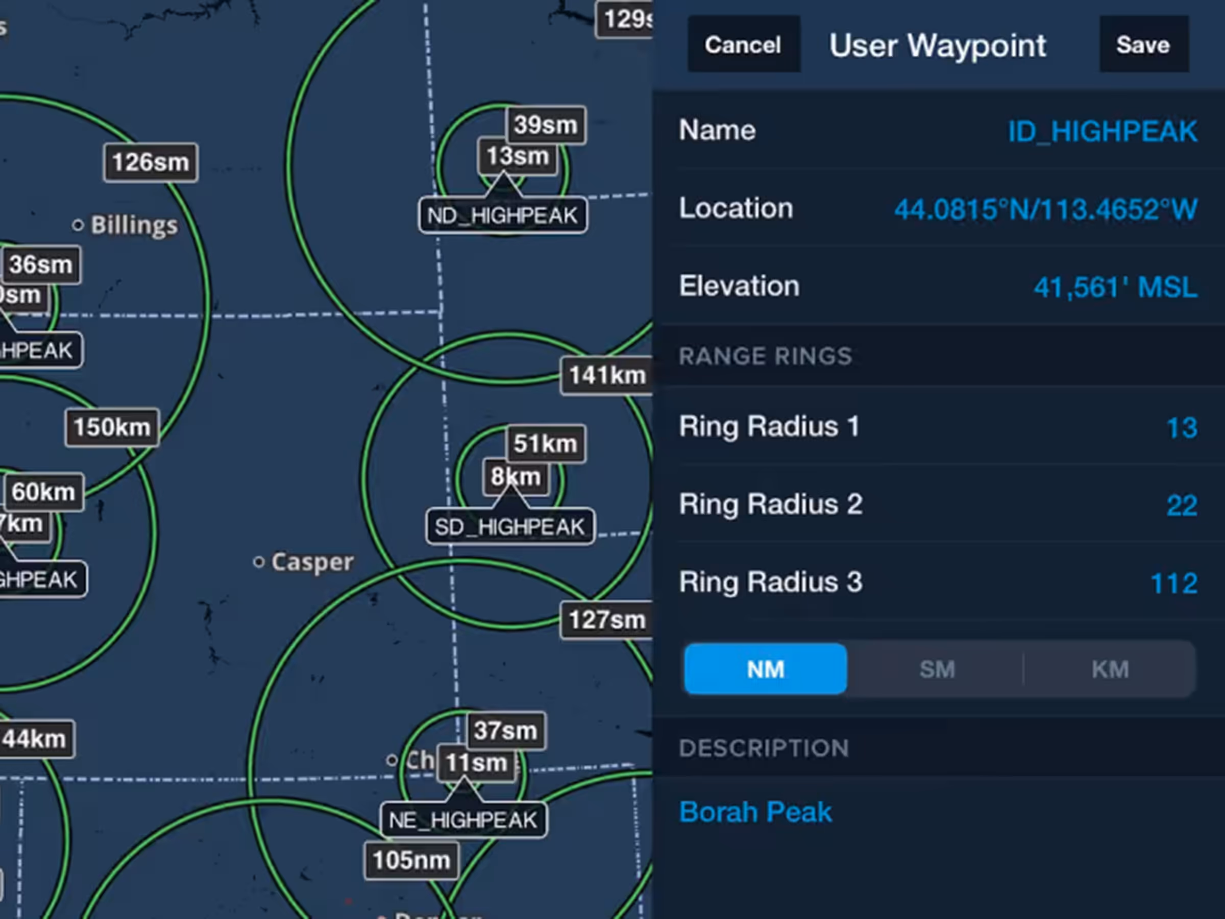
MFB One - User Waypoint Range Rings
- Identify ROZs, avoidance or target areas, and more by marking User Waypoints with up to three customizable range rings that you can toggle on/off.
- When creating or editing a user waypoint, specify radii for up to three rings in either nautical miles, statute miles, or kilometers.
- Tap any user waypoint with rings to toggle them on/off.
- When importing User Waypoints via .csv, either on its own or in a Content Pack, add column headers for RangeRing1, RangeRing2, RangeRing3, and RangeRingUnit to define Range Rings for any waypoint in the .csv.
- Available with ForeFlight’s Military Flight Bag One subscription plan.
New Runway Analysis Aircraft Support
- ForeFlight’s advanced Runway Analysis product for turbine aircraft now supports the following aircraft models:
- Challenger 350/3500
- Falcon 2000LXS/S