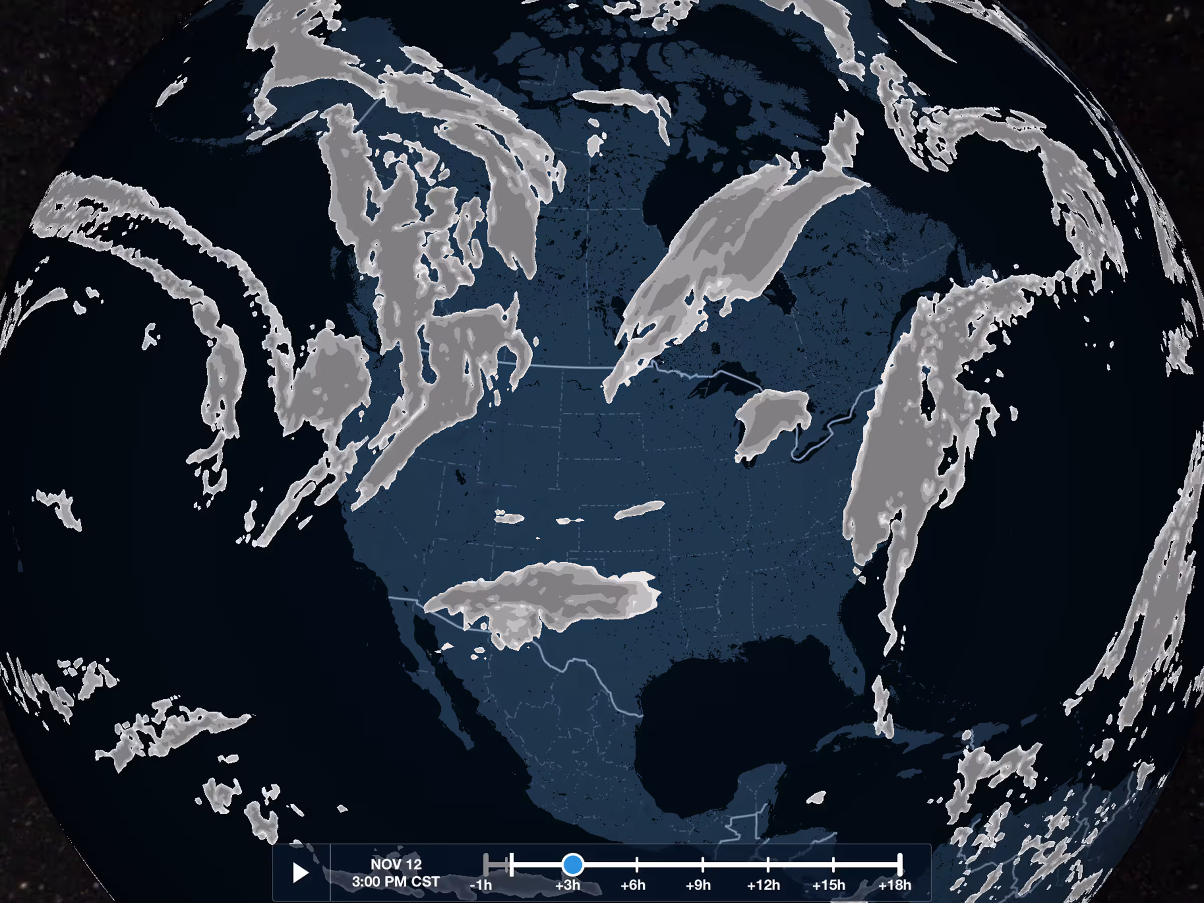
Cloud Coverage Forecast Map Layer
- Get a more complete view of forecast global cloud coverage during flight planning with the new Clouds map layer.
- Enable the Clouds layer in the Maps view Layer Selector, just below the Icing and Turbulence layers.
- The layer is based on the GFS Cloud Coverage product and depicts different forecast percentages of cloud cover over different areas using shades of gray.
- Like the Icing and Turbulence layers, Clouds uses both an altitude and time slider to view forecasts at different altitudes and times, and the layer’s data can also be downloaded for offline use using Pack.
- The Clouds map layer is included in Essential and MFB Pro subscription plans and above, and Business Performance plans.
Clouds in Profile View & 3D Preview
- The same Clouds forecast layer is also available in Profile View and 3D Preview.
- Like the Icing and Turbulence layers, you can enable Clouds using the layer selectors in the lower-left of both Profile View and 3D Preview to display forecasted cloud coverage at multiple altitudes along your route.
- Both Profile View and 3D Preview combine all relevant forecast periods into a single depiction that aligns with your flight’s planned departure and enroute times.
- Clouds and other weather layers in 3D Preview and Profile View are included in ForeFlight Premium and Business Performance subscription plans.
Internet Traffic in 3D Airports
- View live Internet Traffic via FlightAware in 3D Airports to analyze airport activity, follow takeoffs and landings, and more.
- When viewing an airport in 3D, tap the new layer selector in the bottom left and select Traffic to display any airborne traffic near the airport. Unlike the Traffic map layer, 3D Airports does not display ground traffic.
- Traffic targets appear as blue diamonds showing their tail number and current altitude.
- Tap on any traffic target to display its vertical and horizontal track as a blue curtain like in 3D Review. 3D Airports only shows an aircraft’s movement from the time you opened the view or enabled the Traffic layer.
- 3D Airports with Traffic is included in ForeFlight Premium and Business Performance subscription plans.
Additional Mountain Peak Markers
- ForeFlight’s High Resolution Basemap displays more mountain peak markers near terminal areas and elsewhere for enhanced hazard awareness.
- Zooming the map into any terminal area will reveal all peaks and associated altitudes within 15nm of the airport, and zooming into any mountainous region will display a greater number of peaks as well.
- Download the High Resolution Basemap for different regions around the world in More > Downloads.
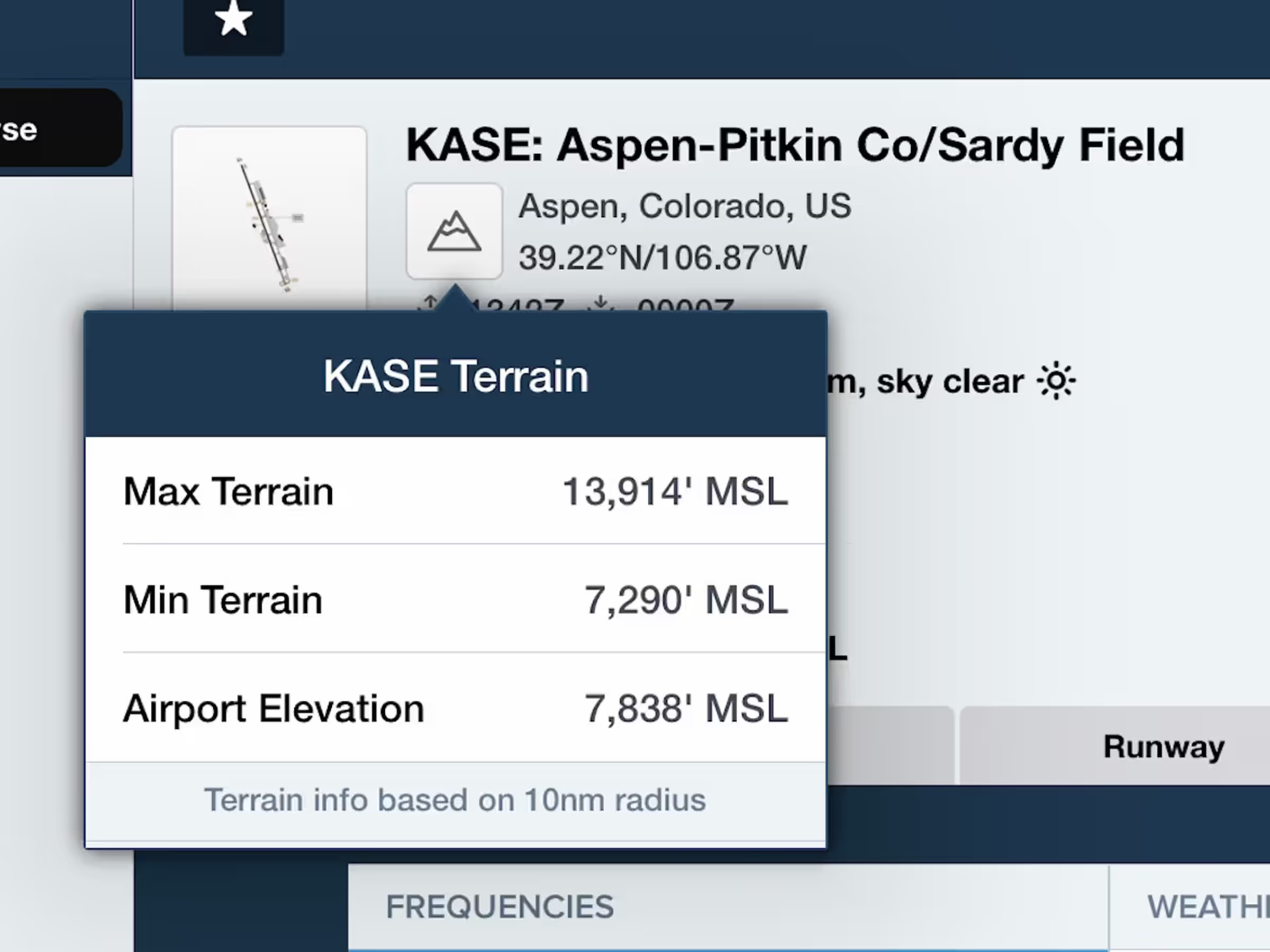
Airport Terrain Information
- Quickly get a sense of the terrain variations near an airport by tapping the new Terrain button in the Airport Summary view.
- The Terrain button appears just to the right of the airport’s taxiway thumbnail on the Airports view or in the airport popup elsewhere in the app. The button only appears for airports in mountainous areas to indicate the presence of major terrain features.
- Tap the button to view the maximum and minimum terrain elevations within 10nm of the airport, as well as the airport elevation.
New Street & Aerial Map Styles
- Both the Street Map and Aerial Map layers have improved styling.
- The Aerial Map has more prominent street and place labels to help you identify features on the map.
- The Street Map uses a new style that continues showing topographical information even at very high zoom levels.
- Both map layers require an internet connection to view.